My friend, Jade, came to visit at the beginning of June. We did quite a few hikes together and Skyline was the biggest beast of them all. It's a bit confusing because the trail head signage as well as trail guides say it's a 1 mile hike. However, the trail continues up past that mile to then traverse the ridgeline of the Mystery Mountains and eventually meets up with the Fuller Lakes Trail. Apparently, the "top" of Skyline trail is a view point a mile up but if you keep going, you come to a meadow type area with amazing views, wildflowers, and a cache box with a journal that hikers sign in to and also leave goodies in. We went approximately two miles (Jade was wearing a pedometer) but never reached that alpine saddle. A fellow hiker had told us of the cache box on the way up and I had wanted to get to it, but in the end, not knowing about the view, I decided two miles of nearly straight up hiking was good enough. Now I feel like I might have to do this bitch again, so I can get to the real top and not feel cheated.
The trail is at mile 61 of the Sterling Highway. It begins at an elevation of 450 ft and has a gain of 1800 feet in 1 mile. It is strenuous and one section in particular of wide, steep, loose dirt takes lots of careful navigating. Sliding down that hill would probably mean a trip to the ER. In all, the trail is more effort than I usually like to expend but the views, even at the fake top, and the feeling of accomplishment are worth all the cursing and complaining it takes to get there.
 Not even close to the top and we started at approximately the same elevation as the lake.
 A sample of the terrain, we had just come over that lip of rock you can see. Jade actually bloodied a finger at one point.

View along the way.
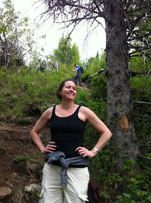 Jade waiting patiently for me to drag my wheezing carcass up another few feet. The man behind helps illustrate the angle. And that was an easy part
 Yay! We're doing it!
 Another viewpoint.
 Another example of the terrain.

 Not even close to the top and we started at approximately the same elevation as the lake.
 A sample of the terrain, we had just come over that lip of rock you can see. Jade actually bloodied a finger at one point.
 View along the way.
 Jade waiting patiently for me to drag my wheezing carcass up another few feet. The man behind helps illustrate the angle. And that was an easy part
 Yay! We're doing it!
 Another viewpoint.
 Another example of the terrain.
No comments:
Post a Comment